Africa’ The Birthplace of Mankind
Since for Africa, experts had earlier determined that it is the origin of mankind, as enormous quantities of human-like fossils (discovered no where else) were uncovered on the continent, some going back 3.5 million years.
About 1.75 million years ago, early man expanded over areas of Africa.
They were ferocious hunters, lived in caves and needed fire and their skills to produce stone tools merely to survive.
Around 200,000 years ago, the Neanderthals emerged and spread throughout southern Europe and portions of northern Africa.
There is also convincing evidence that they possessed control of fire, lived in caves, as well as open-air constructions of stone and plants.
The invention of stone tools was one of prehistoric man’s most significant innovations.
By 5000 BC, farming had become relatively widespread in northern Africa, where humans were raising crops and managing cattle.
During that time the Sahara Desert was a productive place.
History: Ancient Africa
In 3200 BC the Egyptian civilization evolved on the lower banks of the Nile River; it was among the oldest civilizations and its tools and weapons were fashioned of bronze.
They also pioneered the building of enormous pyramids and temples.
In addition, the Egyptians invented mathematics, a ground-breaking medical system, irrigation and agricultural production methods, writing, and the first ships.
In conclusion, the Egyptians had a significant impact on the world.
In North Africa, tiny farming communities and populations began to utilize metal tools around 600 BC. Over time, this use moved south into what is now South Africa.
Between 1550 BC to 300 BC, the Phoenicians, an intrepid maritime commerce culture from Lebanon, moved throughout the Mediterranean.
They established Carthage in what is now Tunisia, North Africa, in 814 BC, only for it to be destroyed by the Romans in 146 BC.
While this was going on, Ethiopia and Sudan saw the establishment of kingdoms as the Egyptians began to extend their civilization over Northern Africa.
Egypt became a province of Rome in 30 BC, and Morocco did so in 42 AD, as the then-expanding Roman Empire proceeded to broaden its sphere of influence.
The Roman Empire fell before the Middle Ages, and the Arabs swiftly displaced them on the continent.
They conquered Tunis and Carthage in 698–700 and soon held control of the whole coast of North Africa.
The majority of North Africa adopted Islam after the Arabs, with Ethiopia being the exception.
Soon, kingdoms began to form in Africa; they conducted commerce with the Arabs using both gold and slaves, a valued commodity.
Ghana, which is today southern Mauritania and western Mali, was one of the early kingdoms.
The trans-Saharan commerce in salt and gold made the empire wealthy, but it fell from power in the eleventh century.
On the continent, other kingdoms arose, notably those in Mali and Benin EMPIRE.
Both grew wealthy through the trade of slaves, horse salt, and of course, gold.
They were also conquered and ultimately destroyed, much like the majority of kingdoms on any continent before them.
Arab traders who traveled and traded on Africa’s east coast founded Mogadishu, currently the capital and largest city of Somalia.
Zanzibar, which served as a platform for journeys between the Middle East and India, was also under the Arabs’ sphere of influence.
The Portuguese started to explore the western coast of Africa while other structured kingdoms emerged in central and southern Africa.
The Cape Verde Islands and the Senegalese coast were reached by them in 1445, and the mouth of the River Congo was reached in 1482.
Even the Cape of Good Hope has sailed around by them.
Also Read: The Benin Empire
Colonization of Africa and the Slave Trade
Beginning in the 16th century, Europeans began bringing African slaves to the Americas for commercial purposes.
A slave might get 45 pounds on the American market for a slave bought on the African coast for the equivalent of 14 English pounds in bartered goods.
The Triangular Trading System was the most well-known form of trade at the time.
It entailed the export of manufactured commodities from Britain and other European nations to Africa, the transport of slaves to the West Indies from there, and the shipment of sugar and other goods back to Europe.
Thousands of ships were taken prisoner by Barbary pirates around the coast of North Africa at the same period.
An estimated 800,000 to 1.25 million persons were abducted as slaves during the sixteenth and nineteenth centuries.
However, the early to middle of the 17th century saw the height of the pirates’ influence on the continent.
Early in the 16th century, the Portuguese colonized what is now Angola, and when news of the riches of Africa reached the north, the Europeans established their first true colonies.
Later, in what is now South Africa, the Dutch established a colony.
The late 18th century saw the start of significant anti-slavery campaigns.
In 1794, France became one of the first nations to outlaw slavery.
Although the slave trade was outlawed in Britain in 1807, it wasn’t completely outlawed until 1848.
Slave-like behaviors are still in use in some regions of Africa and are hard to eradicate.
When the British seized the Dutch Colony of South Africa in 1814, the widespread colonization of Africa by European nations officially started.
The British, Dutch, French, Germans, and Portuguese snatched up every piece that was left after being divided up like a big pie.
By the end of the 19th century, European forces had almost taken control of the whole continent, from Algeria to Zimbabwe and from Botswana to Niger.
As the British seized power in Egypt at the beginning of the 20th century, the land grab continued.
Alter was in the air by 1920 as Europe’s attitudes against the forcible takeover of African countries started to change.
Africans were also propelled by their intense yearning for freedom, which ignited an unstoppable movement.
Most of the continent had gained independence by the middle of the 20th century; Angola became free for good in 1975.
Africa after colonization
The newly developed nations saw more than their fair share of civil wars, coup d’états, and ethnic conflicts as a result of self-government.
Africa was already on the verge of collapse when horrific genocides, famines, and an uncontrollable illness (HIV/AIDS) were added to the equation. In many places, this is still the case today.
Despite the fact that there are over one billion people living there and more than 2,000 languages spoken there, Africa continues to be the continent with the poorest population in the world.
Over the past few years, significant economic and social advancements have been made, with South Africa, Nigeria, Morocco, and Egypt leading the way.
Agriculture and mining make up the bulk of contemporary Africa’s economies, with tourism expanding in some regions.
Manufacturing sectors have expanded to the point that they can send goods anywhere on the earth, and Angola, Libya, and Nigeria’s oil export income have the power to drastically alter the lives of millions of people.
The 54 nations that make up Africa now have a lot of promise, but it is necessary to pose the question, “Can it evolve quickly enough to satisfy the demands of its people?”
All we can do is hope so.
The Map of Africa
Africa is the second-largest continent on Earth and the continent with the second-highest population (after Asia).
It is made up of 54 different countries, as well as the disputed state of Western Sahara, which is a member of the African Union.
Notably, South Sudan is the region’s newest nation. With 1,032,532,974 inhabitants as of 2011, it represents just over 14% of the world’s population of people.
It also has the longest river system in the world, the Nile, and the biggest desert in the world, the Sahara.
Africa is surrounded by the Mediterranean Sea to the north, both the Suez Canal and the Red Sea along the Sinai Peninsula to the northeast, the Indian Ocean to the east and southeast, and the Atlantic Ocean to the west.
Outline of an African country map
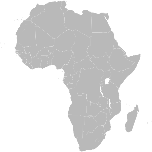
Continent of Africa in outline, showing the Western Sahara, which is a contentious area.
Africa Political Map
Political maps are designed to show governmental boundaries of countries, states, and counties, the location of major cities, and they usually include significant bodies of water.
Bright colors are frequently used to make borders easier to find, just like in the sample.
Here is a larger version of this map.
Topographical Map Of Africa
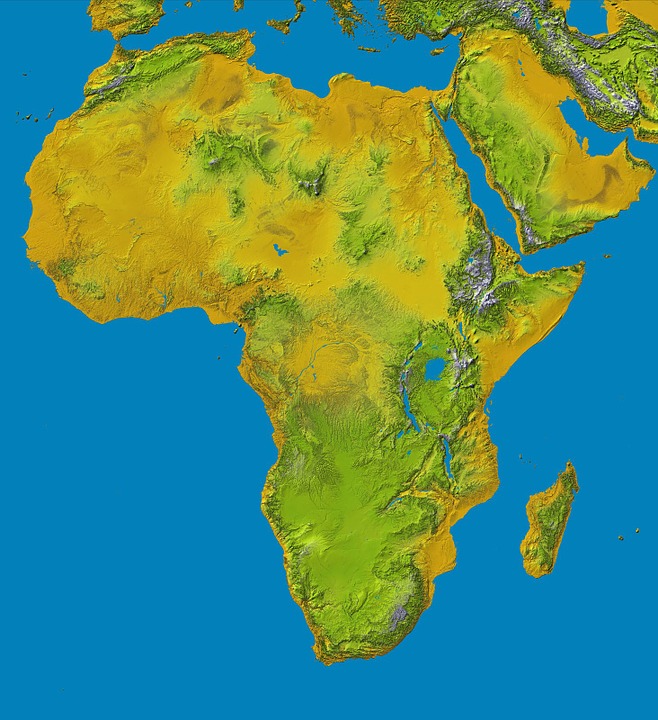
A topographic map accentuates hills, mountains and valleys of a given land region by enhanced shading rather than by utilizing contour lines.
This topo map vividly displays the flatness of the Sahara Desert, the depression that Lake Chad rests in, the high mountains of the Great Rift Valley, and it also highlights Lake Victoria, all but ringed by mountains.
Great Rift Valley African Map
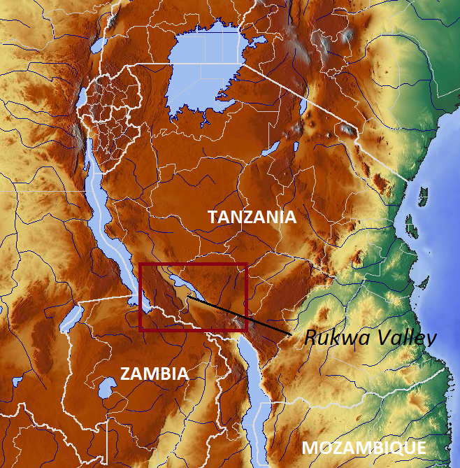
This is a portion of a bigger topographical map that shows the Great Rift Valley, a striking depression on the earth’s surface that stretches from the Red Sea region near Jordan in the Middle East, south to the African nation of Mozambique. It is about 4,000 miles (6,400 km) long.
The Ethiopian Highlands are essentially a chain of geological faults that were constructed by massive volcanic eruptions that occurred thousands of years ago.
Along its entire length, these faults have produced vertical cliffs, mountain ridges, rough valleys, and extremely deep lakes.
The Rift Valley is surrounded by several of Africa’s tallest mountains, including as Mount Kilimanjaro, Mount Kenya, and Mount Margherita.
Map of Africa in satellite view
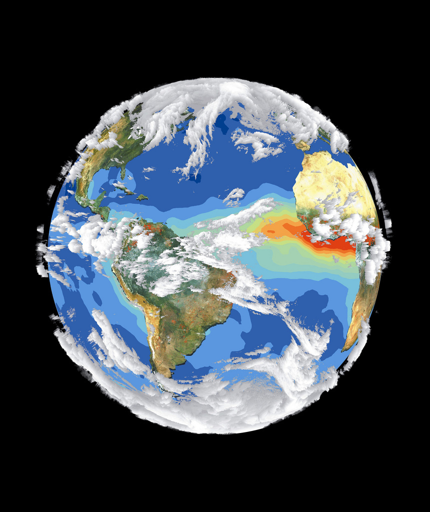
Applications for this NASA satellite image of Africa include agriculture, geology, forestry, meteorology, intelligence, and military, among others.
Additionally, it’s a fantastic educational tool since it gives a general picture of Africa, showing the northern desert parts, the lush center regions, and the diverse terrain of the southern portions of the continent.
1570 Historical African Map
The map’s exquisite design, which displays Africa in a recognizable form with a more pointed southern tip, is a high point of 16th-century cartography.
While there, vast empty expanses start to predominate, Madagascar appears as well as the place-names of various settlements along the coastlines and in the interior.
There is no mention of any plants or animals, yet there are whales and swordfish in the waters.
Three ships are obscured in the smoke of combat in the lower right.
Abraham Ortelius, who produced the Theatrum, the first atlas, created the map.
Africa Before Colonization Map
A map created in 1812 by Arrowsmith and Lewis and published in Boston by Thomas & Andrews shows Africa before colonialism.
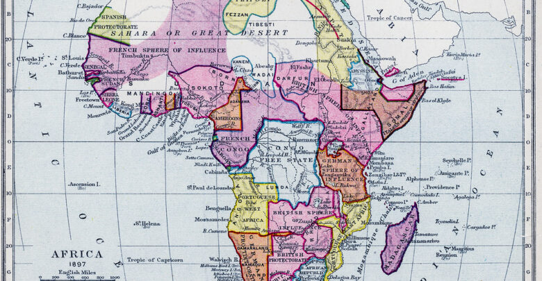
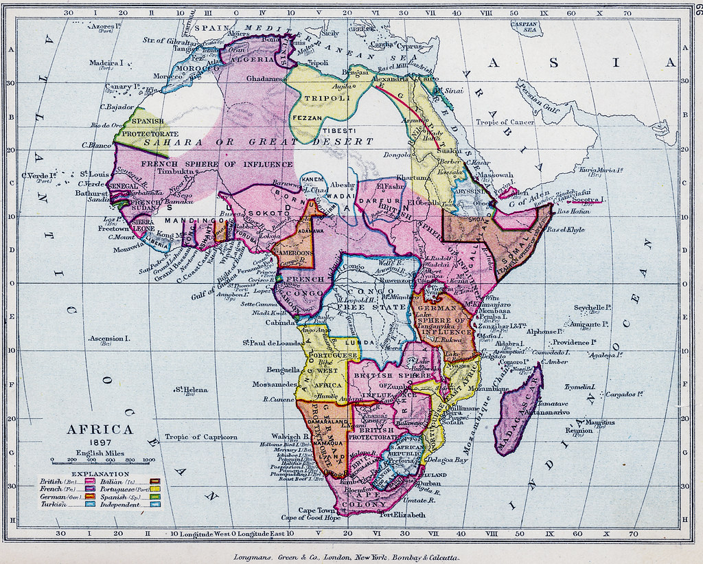
1910 Map of African Colonization
Advertisment