African Borderland Communities and Colonial Borders in Africa

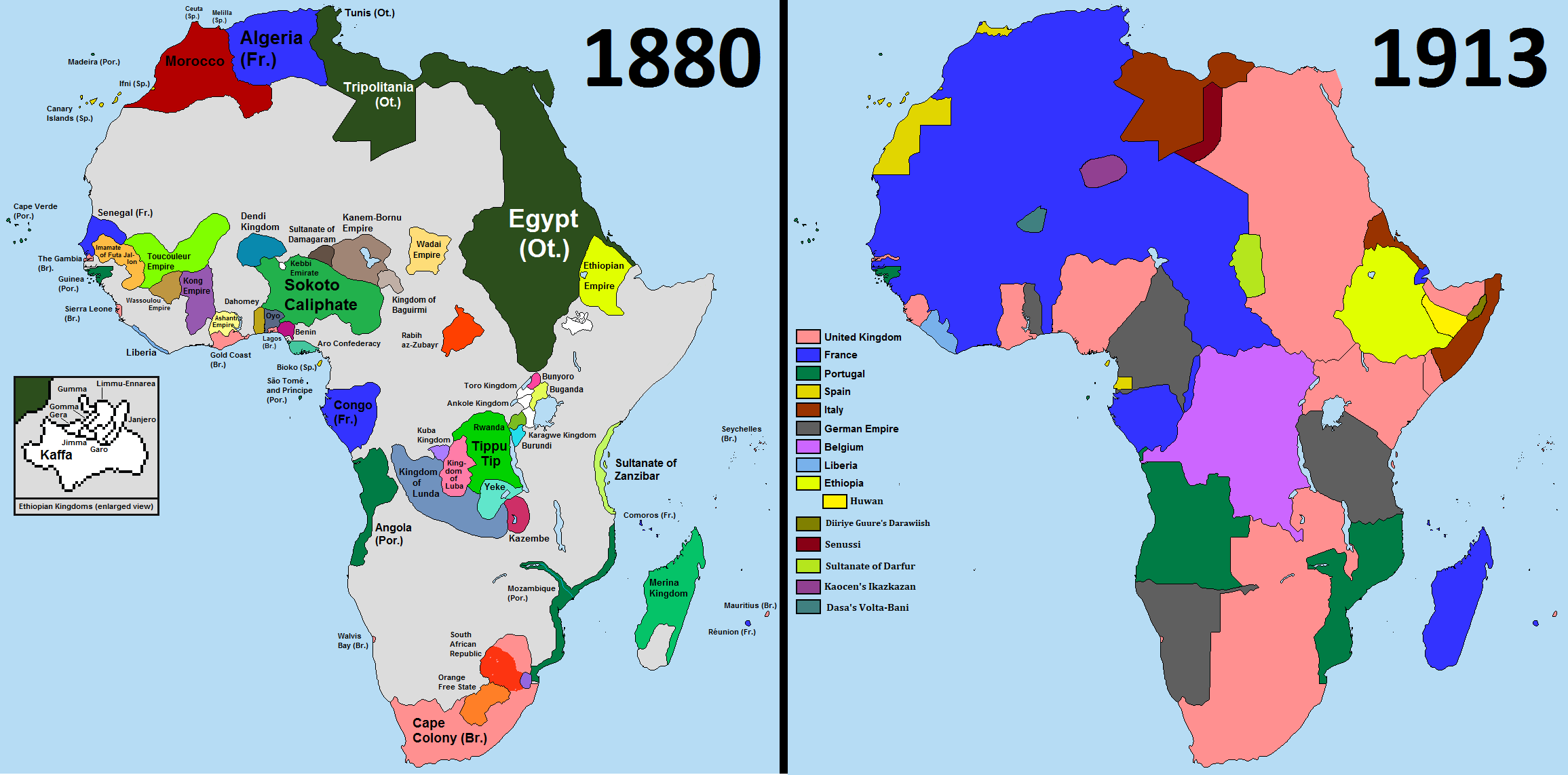
The Berlin Conference (1884–1855) marked the start of the Scramble for Africa, which was resolved by the early 20th century.
During this time, European colonizers divided Africa into many regions, colonies, and spheres of influence.
Without having a thorough understanding of the geography, history, and ethnic makeup of Africa, they divided territories away from European capitals.
A sizeable component of the population in many African nations comes from ethnic groupings divided by colonial boundaries.
When colonialism first began, European powers interacted with African chieftains and local authorities preferentially.
In order to gain territory and draw boundaries, colonial powers used shady tactics like coercion, fraud, intimidation, and bribery.
Additionally, colonial powers used a variety of strategies to sway African leaders and acquire areas rich in resources.
Also Read: What was the Purpose of the Berlin Conference

The Berlin Conference legitimized the division of Africa
Colonialists created regional maps without consulting the African local leaders and concluded treaties among colonial powers to prevent competition for resource use.
But because of their incomplete understanding of the continent and the state of the available maps, they made a lot of mistakes.
At the signing of the Anglo-French convention on the Nigeria-Niger boundary in 1906, Lord Salisbury, the British Prime Minister at the time, exemplified this arbitrary and uninformed approach when he said:
“We [the British and the French] have been engaged in drawing lines upon maps where no white man’s foot has ever trodden: we have been giving away mountains and rivers and lakes to each other, only hindered by the small impediments that we never knew exactly.
Fictitious Borders
This phrase clarifies how colonial powers created fictitious borders in Africa without taking into account the geography or native populations.
Between 1900 and 1930, European nations used boundary commissions to perform cartographic surveys of their domains, giving them complete authority over colonies.
These, however, ignored the effects of partitioning on ethnic groupings and instead concentrated only on land control.
Many closely related ethnic groupings were divided by artificial borders and colonial regions.
For example, they divided Somalis into French Somaliland, British Somaliland, Italian Somaliland, Ethiopian Somaliland, and the Somali territory of northern Kenya in the Horn of Africa.
These colonial borders have a significant impact on Somalis who live as separate citizens of Ethiopia, Djibouti, and Kenya despite sharing a same culture, a common way of life, and a common religion.
The Anyuaa and Nuer of Ethiopia were divided between Ethiopia and South Sudan, and the Afar of Ethiopia were divided between Ethiopia, Eritrea, and Djibouti.
Also Read: Sub-Saharan Africa: History, Geography, Politics and Racist Undertone
Impact of Borders in Africa
African communities were unable to move freely in their everyday lives and nomadic ways as a result of artificial border designs, which caused economic hardship and social unrest.
The traditional way of life, organizational structures, and economic well-being of African communities were adversely affected by changes to their structural and lifestyle systems.
By restricting their mobility and making them live in ways that were foreign to their customary way of life, this deprived communities in the African borderlands of economic opportunities.
For instance, many pastoralist and nomadic Africans require large tracts of land for grazing and water.
Artificial boundaries, on the other hand, forced borderland inhabitants to compete with each other for resources and engage in conflict as a result of their restricted mobility.
The “divide and rule,” “direct rule,” and “assimilation” strategies used by European colonial powers, in addition to poorly drawn borders, forced Africans to lose their social norms, identities, and social order.
Additionally, these practices sparked confrontations among the locals, further separating them and enhancing colonial power.
As a result, borderland residents progressively began to harbor animosity among one another, and post-independence African governments and political elites exploited this split for political ends.
Also Read: The Map of Africa
Political Impact Borders in Africa
Some political elites in Africa have stronger ethnic affiliations, and they play significant roles in rising political disenfranchisement and escalating tensions.
For instance, while belonging to the same ethnic group and sharing a border with Ethiopia and South Sudan, the Jikany-Nuer of Ethiopia and the Lou-Nuer of South Sudan are regarded as two separate ethnic groups with unique nations and have grown hostile due to resource competition.
African political leaders have not helped to ease the disadvantages of colonization and artificial borders on borderland people; instead, they have utilized them as political props.
The division of ethnic groups and improper border design have led to underdevelopment and instability in African republics.
Additionally, the separation between the core and the peripheral was shown by certain people being excluded. The difficulties are made worse by borderland communities in African states.
The borderland populations are exposed to a multitude of human security issues, including widespread poverty, a lack of infrastructure, inadequate education, and cross-border intergroup disputes due to the lack of economic, social, and political development as well as limited upward mobility.
For borderland populations all over Africa, instability and underdevelopment have worsened as a result of the erroneous construction of African borders and the use of these designs as political tools.


