From northern Syria to central Mozambique in East Africa, the great rift valley Africa is a physical and geological feature that runs north to south for about 4,000 miles (6,400 kilometers).
It is the most prominent physical feature of the planet that can be seen from space, according to astronauts.
Africa’s landscape varies from high, snow-capped mountains to salt plains that are more than 500 feet (152 meters) below sea level.
The Rift is renowned for its breathtaking landscapes and plentiful, occasionally rare, species.
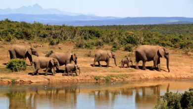
There are around thirty lakes along its length; the three biggest in Africa are referred to as the Great Lakes and include the second-deepest lake in the world, Lake Tanganyika, and the second-largest freshwater lake by surface area in the world, Lake Victoria.
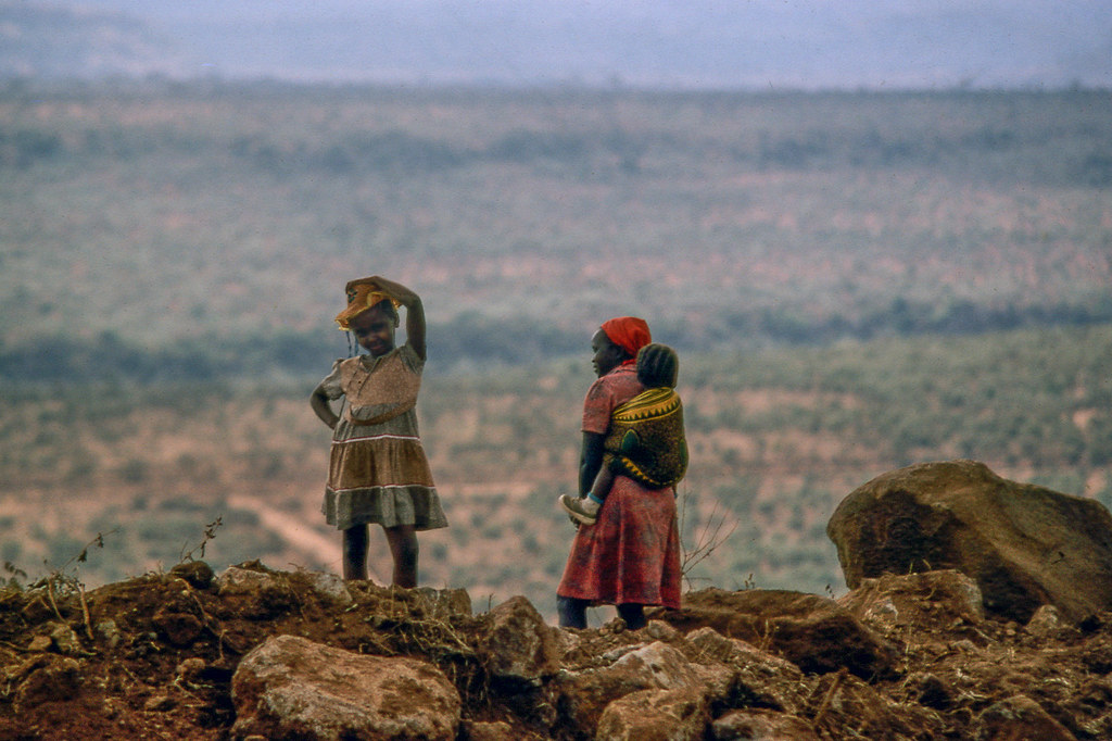
The African section of the valley has some of the earliest human skeletal remains.
Also Read: Cichlids in Lake Tanganyika
Earlier Exploratory History of the Great Rift Valley Africa
Snow was reportedly present at the equator, but the first European explorers to reach Central and East Africa were originally disbelieved.
To find the source of the Nile, the Royal Geographical Society dispatched an expedition to the area.
Eduard Suess, an Austrian geologist, developed his idea that the network of valleys and lakes that spanned Arabia and Africa was a continuous trough with the assistance of the thorough reports from that expedition.
He wrote a study in 1891 that related motions within the Earth to the geology and structural geography between Syria and Malawi.
The next year, John Walter Gregory, a British explorer, started his journey into East Africa. He came to the conclusion that faulting, not erosion, had built the great rift valley Africa to which he gave the term “Great Rift Valley,” the name currently used for the whole African Rift. This was based on comparisons of geological layers.
What is the Great Rift Valley known for?
One of the Seven Wonders of Nature. The great rift valley Africa is home to some of the world’s most breathtaking vistas and pristine ecosystems.
Also Read: Tanzania Ngorongoro Crater Conservation Area
Tanzania Ngorongoro Crater Conservation Area – The Biggest Crater in the World
Where is the Great Rift Valley located?
The great rift valley Africa is situated along a fault line that extends from Mozambique through Tanzania, Kenya, and Ethiopia before ending in Mozambique.
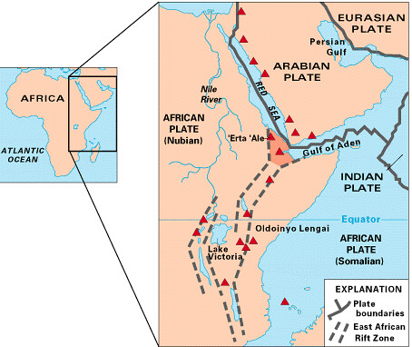
Map of the Great Rift Valley Africa
Redgeographics’s great rift valley Africa Map, CC BY-SA 4.0
How was the Great Rift Valley Formed
The East African Rift and the great rift valley in Africa were formed by the separation of tectonic plates around 40 million years ago. This geographical depression is over 6000 kilometers long (3700 miles).
Why is the Great Rift Valley Important
Hot springs, geysers, volcanoes, and regular earthquakes are all well-known features.
With regard to the significant paleoanthropological discoveries in Ethiopia, Kenya, Tanzania, Uganda, and Zaire, it provides the ideal habitat for comprehending the development of humanity.
Also Read: Victoria Falls in Zimbabwe and Zambia’ “The Smoke that Thunders”
Victoria Falls in Zimbabwe and Zambia’ “The Smoke that Thunders”
Great Rift Valley facts
How the Great Rift Valley Africa was Named
The continuous long trench that runs through the surface of the earth for around 3,700 miles (6,000 km) is known geographically as the Great Rift Valley.
From Lebanon’s southern border with Syria and Israel to Mozambique and South Africa, this rift valley with freshwater lakes stretches.
This valley’s name derives from its position in the African continent, where it scars the African Plate. During an expedition by the British geologist John Walter Gregory in 1864, the concept of naming his geological feature first came to him.
Gregory noted that some of the exposed layers in an East African rock formation appeared to have been torn apart (like taffy), while others appeared to have been pressed together.
He came to the conclusion that powerful forces must have once split and gradually pushed apart the African continent.
The great rift valley Africa, also known as the East African Rift System, stretches from northern Syria to central Mozambique, covering an area of nearly 2,400 km in length and 160 km in width.
The African plate and the Arabian plate are divided by a valley. In addition to the numerous springs and lakes that cut through the valley floor, central Kenya also has volcanic highlands.
Great Rift Valley Lakes
Some of the most stunning lakes on earth may be found in East Africa’s Great Rift Valley. The biggest freshwater lake in Africa and one of the great lakes of the world, Lake Victoria, is the most well-known of these.
The most well-known lakes in the great rift valley Africa are Lake Tanganyika, Lake Victoria, Lake Malawi (Lake Nyasa), Lake Albert, and Lake Turkana (Lake Rudolf). Another intriguing collection of endemic species is found in Lake Tanganyika, which is shared by Tanzania, the Democratic Republic of the Congo, and Burundi.
These species include fish, cichlids, mollusks, and snails. The Great Rift Valley in eastern Africa is home to one of the largest and deepest lakes in the world, Lake Tanganyika. It is 32,893 square kilometers in size and 2,536 feet above sea level (773 m).
After Lake Baikal, it is the second-deepest freshwater lake in the world. Another sizable lake created by rifting processes along this section of Afar’s eastern border is Lake Malawi, or “Nyasa” in Malawi. Lake Turkana, originally known as Lake Rudolf, is located in Kenya.
The Blue Nile’s source lake, Lake Tana, as well as Lake Abbe are located in Ethiopia’s rift valley. The Lakes Shala, Zway, and Hayk or Mariam are the other Rift Valley lakes in Ethiopia.
Read More: The African Great Lakes
Ranges Of Mountains In The Great Rift Valley
The Rwenzori Mountains in Kenya and Tanzania, Mount Cameroon, and Mount Kilimanjaro are among the mountains in East Africa’s Great Rift Valley.
The great rift valley in Africa is a network of valleys and lowlands that stretches from Mozambique in South-East Africa to the Dead Sea in the Middle East.
The Jordan, Palestine, and Sinai Peninsulas, the Central Red Sea Mountains, the Omo-Turkana Basin, the Western Great Rift Valley, the Eastern African Rift, the Lake Baikal Rift Valley, and the Tongariro-Kaukau Geothermal Field are all part of this region.
The volcanic mountains of Mount Meru, Mount Kilimanjaro, Mount Elgon, Mount Kenya, Mount Nyiragongo, and Mount Karisimbi, as well as the highlands of the Tanzanian Rift, all exhibit volcanic eruptions and extraordinary accumulations of centers.
The oldest natrocarbonatite-containing volcano in the world is another Ol Doinyo Lengai volcano, which is still active. The tallest mountains, including Mount Kilimanjaro and Mount Margherita, are located in the western Rift.
Also Read: Lake Natron In Tanzania’ The Medusa Water that turns Animals into Stone
Lake Natron In Tanzania’ The Medusa Water that turns Animals into Stone
Great Rift Valley Climate
The Great Rift Valley’s climate changes according to height. The highlands, which include the Mau Escarpment in Kenya and the high plateau of Ethiopia, are arid with chilly evenings in certain parts but comfortable during the day (although rain is more likely on higher ground).
When the sun is high in the sky, it may be quite hot on the Great Rift Valley floor, but it can also be fairly nice in the early morning and late evening.
While Sudanese and Kenyan sugar cane farms may border large deserts, deserts transition into savannah grasslands at lower elevations, especially in places below sea level like Khartoum and Lake Nasser. In the protected areas for animals, the earth’s surface is rocky.
A group of freshwater lakes in the East African Great Lakes, notably in the trough of the East African Rift, are known as the Great Rift Valley lakes.
There are several saltwater lagoons, numerous smaller lakes, and eight large lakes. In the Kenyan highlands, the average maximum and lowest temperatures range from 75.2 °F (24 °C) to 57.2 °F (14 °C).
On the western slopes of Mount Kenya, the average annual rainfall is 20 in (500 mm), whereas it is 47 in (1,200 m) close to Mount Kilimanjaro.